
DOWNLOAD THE APP


Customer Services
Copyright © 2025 Desertcart Holdings Limited
DOWNLOAD THE APP
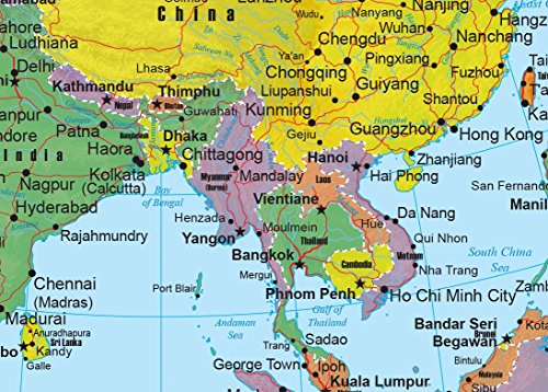


🗺️ Elevate your space with Asia’s most dynamic wall map—where precision meets style!
The Asia Wall Map GeoPolitical Edition by Swiftmaps is a 24x30 inch laminated map combining detailed political boundaries with a 3D shaded physical relief layer. Crafted on heavy-duty paper with a durable 3mil lamination, it offers long-lasting use and annual updates to reflect current geopolitical changes. Ideal for education, business, or stylish décor, it comes with a satisfaction guarantee for confident purchasing.
| ASIN | B06XR8FD4R |
| Batteries required | No |
| Customer Reviews | 4.3 4.3 out of 5 stars (71) |
| Import | Made in USA |
| Is Discontinued By Manufacturer | No |
| Item Weight | 3.2 ounces |
| Manufacturer | Swiftmaps.com |
| Product Dimensions | 18 x 22 x 0.1 inches |
K**B
Great in the Classroom
Wanted a set of continent maps for the classroom and the Swiftmaps ones are the only ones I liked.
G**E
Countries and Capitals of the wirld
I have taken a mission of learning the countries and capitals of at least five continents: North America, South America, Africa, Asia and Europe. It has been challenging and rewarding. However, it has used up a lot of slack time during the Corona Virus hunker down. I have met my goal for all the continents except Africa and Asia, but I am gaining on them. George Bruce [email protected]
L**G
Good quality with bold print !
Shows our grandkids where we are headed on future trips. Now they can track us as we travel.
J**A
Classroom Maps
I’d like more detail in terms of the inclusion of more cities and topographical elements.
K**E
As Expected
Product is as expected/outlined online.
J**H
Perfect
Great addition to the Geography classroom. No more squinting at those all in one wall maps.
M**A
Exactly!!!
Exactly what I was looking for!
J**D
Good
Asia map.
Trustpilot
2 weeks ago
2 months ago