Desertcart purchases this item on your behalf and handles shipping, customs, and support to Ireland.
🧭 Navigate like a pro, wherever the wild calls!
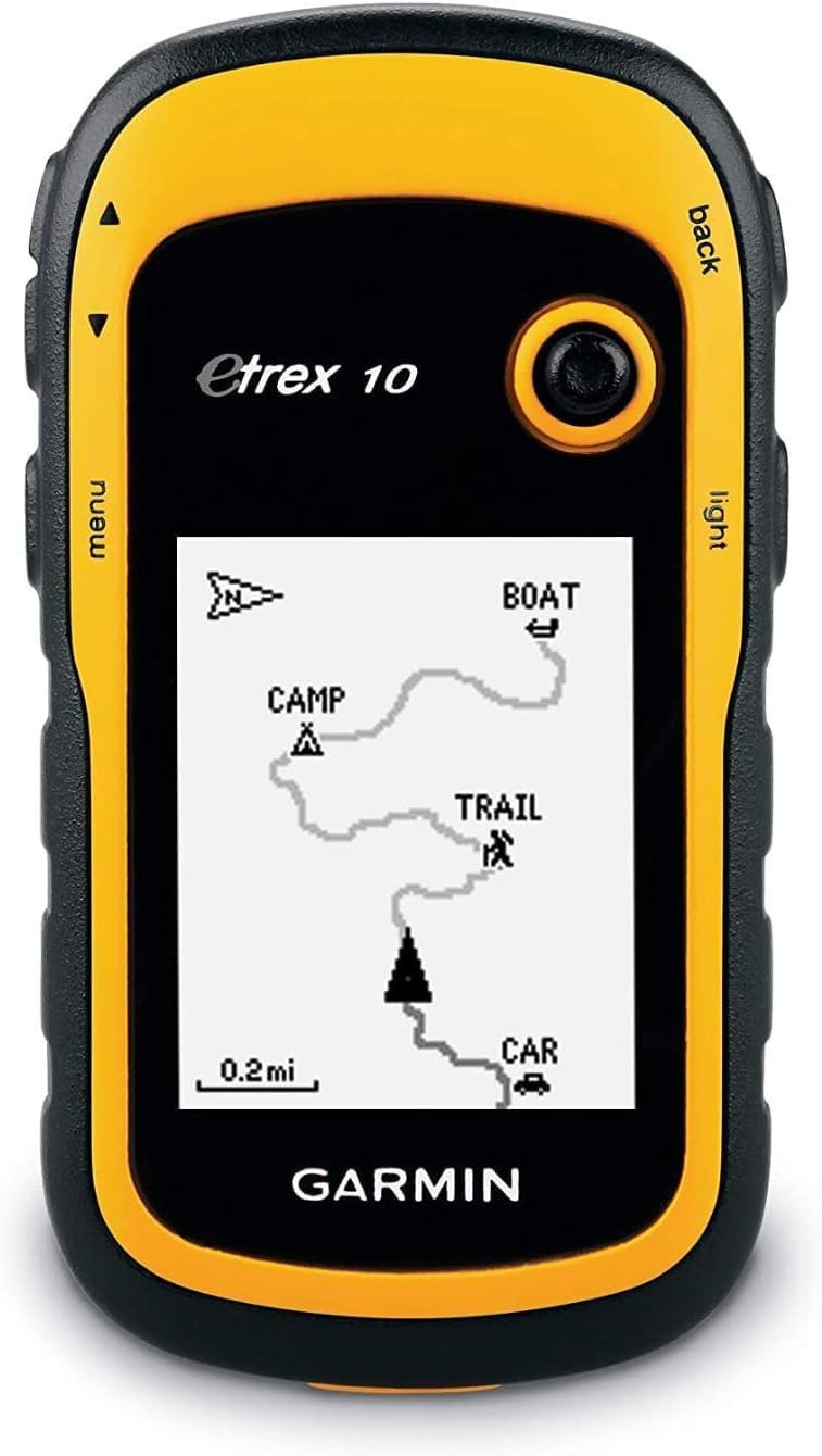
The Garmin eTrex 10 is a compact, rugged handheld GPS unit featuring a 2.2-inch monochrome display optimized for all lighting conditions. Waterproof and built to endure harsh outdoor environments, it offers high-sensitivity GPS with HotFix satellite prediction for fast, accurate positioning. Supporting geocaching GPX files and powered by 2 AA batteries lasting up to 25 hours, it’s the essential navigation tool for hikers and outdoor enthusiasts seeking reliable, no-nonsense waypoint navigation.


| ASIN | B00542NV32 |
| Are Batteries Included? | No |
| Audio Output Mode | Digital |
| Battery Average Life | 25 Hours |
| Best Sellers Rank | 72,269 in Sports & Outdoors ( See Top 100 in Sports & Outdoors ) 10 in GPS Handhelds |
| Brand | Garmin |
| Brand Name | Garmin |
| Compatible Devices | Touch devices, computers, and generally any device that can use USB connectivity or global map |
| Compatible Flash Memory Type | microSD |
| Compatible with Vehicle Type | Car, Truck, Motorcycle, etc. |
| Connectivity Protocol | wired |
| Connectivity technology | USB |
| Control Method | Touch |
| Customer Reviews | 4.3 out of 5 stars 6,353 Reviews |
| Display Type | LCD |
| Global Trade Identification Number | 00753759975845 |
| Item Dimensions L x W x H | 5.4L x 3.3W x 10.3H centimetres |
| Item Weight | 141.7 Grams |
| Manufacturer | Garmin |
| Manufacturer Part Number | 0100097000 etrex 10 |
| Map Coverage Type | Topographic |
| Memory Storage Capacity | 6 MB |
| Model Name | Gps Gerät Etrex 10 Worldwide |
| Model Number | 010-00970-00 |
| Model Year | 2011 |
| Model name | Gps Gerät Etrex 10 Worldwide |
| Mounting Type | Handlebar Mount |
| Network Connectivity Technology | USB |
| Number of Items | 1 |
| Number of Packs | 1 |
| Operating Systems | Garmin |
| Product Features | Handheld; etrex; eTrex®; etrex 10; garmin; GPS; outdoor handheld; outdoor GPS; hiking GPS; walk; walking; trek; trekking; trail; touchscreen GPS; adventure GPS; walking sat nav |
| Resolution | 128 x 160 |
| Screen Size | 2.2 Inches |
| Screen size | 2.2 Inches |
| Special feature | Handheld; etrex; eTrex®; etrex 10; garmin; GPS; outdoor handheld; outdoor GPS; hiking GPS; walk; walking; trek; trekking; trail; touchscreen GPS; adventure GPS; walking sat nav Special feature Handheld; etrex; eTrex®; etrex 10; garmin; GPS; outdoor handheld; outdoor GPS; hiking GPS; walk; walking; trek; trekking; trail; touchscreen GPS; adventure GPS; walking sat nav See more |
| Sport Type | Camping & Outdoor |
| Supported Satellite Navigation System | GPS |
| Touch Screen Type | Resistive |
| UPC | 753759975845 |
| Unit Count | 1.0 count |
| Vehicle service type | Car, Truck, Motorcycle, etc. |
D**K
Excellent bit of kit - used on Dartmoor in 20m visibility for 20 miles
I purchased this last minute, I intended to borrow a friend's older version to use on a 20 mile hike across Dartmoor but decided to go ahead and purchase one for myself as I knew I would use it. I'm certainly not disappointed. The trip across Dartmoor was for charity and the weather seemed to know it. Thick, late summer fog shrouded us all day and although the map said there were paths we quickly discovered there weren't any! This thing literally saved us from getting lost in the fog (visibility was down to 20 metres). I wasn't looking for fancy map screens or anything like that, I just needed something that was going to give me a UK OS grid reference and this does. The batteries lasted ages (the walk was around 9 hours and it was fine, on constantly - 2 AA batteries). It seemed very accurate or at least using it in combination with a map and compass I had no problem getting somewhere with some pacing and micro-navigation so I assume it was pretty accurate! Acquiring signal was also no challenge. I get very warm and sweaty at some points and I had it parked on an inside pocket some of the way and it worked perfectly fine despite being in a sauna! Additionally it rained lightly for some parts of the trip and again, was absolutely fine. It has some other interesting features like using it with mapping software which I use frequently (not tried that yet) and it has a 'nipple scroll' which is extremely handy for navigating menus quickly. It did take some time getting my head around where everything was and the manual which came with it I felt missed a lot of information out so I had to go hunting on forums. I think this is a great gadget and for the price, brilliant. Highly recommended for the typical hiker.
A**R
Garmin eTrex 10 Outdoor Handheld GPS Unit, Black/Yellow
Its Simple to use and is very accurate. I use it for Woodland walks and for the Waypoint Navigation and Trip data. 2 AA Batteries last Ages and will be enough power to cover a whole days walking easily. very rugged and compact and light. A good basic waypoint navigation tool that can be used all over the UK mainly for me. Used for nearly a year on and off and has not let me down yet. If you want something like Google maps... this is not for you. But for a cheaper simple Waypoint Nav device. This is it.
P**C
Persevere, look on YouTube for how to use it and it will reward your time and effort.
Beware! There are no instructions and it is NOT intuitive. That said, once you have gone onto YouTube and watched how others have got to grips with it, it does become easier to understand and to use. Good battery life, it uses standard AA batteries, so easy to replace if you are on a long distance route and able to get to shops on occasions (or carry spares with you). I found this works best combined with OS Maps online. A £20 subscription gives access to all of the site's features, including creating routes and exporting the route as a GPX file to your eTrex10. The "Whereto" function then allows you to access the uploaded route and it is easy to follow once you get to your route start point. It's also good at finding exactly where you are (to within a metre if there are plenty of satellites). It will give you a grid reference that you can then see on your map. It doesn't give you a nice coloured map and show you your route on it, so be careful of your expectations. The (much more) expensive models do that. There IS a way of getting maps onto it, but it's not easy and involves JAVA on your computer and changing the device's internal programming. You can enter map coordinates manually as waypoints, rather than upload as a route, so if you want to navigate to, say, a campsite and you are in the general area, you can call up your named waypoint and it will enable you to navigate to the destination. Be warned though - you have to set the default to "British OS Grid Ref", otherwise it will still be in some USA grid reference mode. This is the basic model, black and white screen, quite slow to "toggle" and not easy to get to know how to use it at first, but I like the price and the functionality and would nevertheless recommend it. Definitely a bit of kit that I will always take with me. I still take a map and compass as well.
R**B
Well worth upgrading to
My first GPS was the original eTrex and has been very good over the years. I upgraded to the eTrex 10 because I needed a second GPS and thought the extra sensitivity and memory would prove usueful. The first thing I liked was the easy to use toggle switch on the front of the eTrex 10 which makes the inputting of coordinates so much easier; the use of very stiff "enter" button with the old eTrex would often result in a tender thumb after a long session of inputting data. To judge the claims of improved sensitivity I went for a walk in a heavily wooded area with both my GPS units. Before entering the woods both GPS units were claiming to know my location within 3mt. As I entered the woods my eTrex's accuracy changed to 5 and then 8mt, the eTrex 10 stayed at 3mt. By the time I was well under cover the eTrex 10 was reading 5mt and 8mt when standing next to large tree trunks. By comparison the eTrex was reading 10 to 20mt. Generally the eTrex 10 appears to be 2 to 3 times more accurate than my old eTrex. Having the extra memory with the eTrex 10 means that no longer do I have to delete routes to make room for new ones. Finally another bonus is when inputting a linear route only one direction needs to be stored as the eTrex 10 can reverse routes with a simple press of a button. Overall an excellent and simple to use GPS and if as reliable as my old unit well worth the money.
S**Y
the instructions are very poor. I had to look at loads of YouTube ...
I would say that the product itself is ok. The build quality is robust. However, as other reviewers have mentioned, the instructions are very poor. I had to look at loads of YouTube videos to get an idea of how to use this for Geocaching. This would be something that the manufacturer could improve fairly easily. This is a very basic model. I guess you get what you pay for. If I had known what I know now, I would probably have paid a little more for one with proper maps. However, that said, it does do the job and we have had a lot of fun with it. The accuracy of the device appears to be spot on. We have navigated successfully to geocaches even when there has been thick tree cover, which one might have expected to interfere with the satellite signal.
W**R
Perfect for my needs
Map reading is not my strong point and this device was perfect for my needs. I was doing a challenge walk and needed to plot the route on an OS map and take with me. With this unit you're able to upload gpx files to it so I logged on to the OS website plotted the route with waypoints, saved and uploaded. I first did a 17 mile test route which was fine, then loaded in the 26 mile challenge route, fine also. There's no proper maps on it as such but for following routes and recording your routes I find it excellent. I've had a colour screen unit before and this is much easier to read in direct sunlight. The first lot of batteries lasted well over 20 hours, it's small and easy to carry or put a lanyard on. It's worth noting the maximum number of waypoints is 250 per route so extra long routes may need to be split up.
P**D
Familiarise
Once you have mastered the functions it's very good.
R**N
Excellent device for mountain travel - instructions very limited
It is very difficult to give a true Star Rating as this little cheap satnav is really very good for mountaineers/adventure travel worldwide but the instructions for its use are woefully inadequate!!! I bought it as I needed a satnav for a ski tour in Norway. Good points are: Nice hand size - rugged - water proof - takes 2 x AA batteries (lithium for cold weather) - has map grids for most countries and UTM (the km2 grid standard for outdoor maps in countires like Norway who don't have their own grid system) - the displays for 'Map' and 'Compass' can be customised to show up to 4 other pieces of information (such as distance to next waypoint or bearing to next waypoint) from a long list of options - information inputing is not too difficult using menues and toggle. The bad points: The manual supplied and the longer downloadable version from Garmin are totally inadequate. This little device is a very capable satnav for the outdoor adventurer but it took me hours and hours of research on Google and various forums to find out how to set the device up for travel in the Norwegian mountains using it in conjuntion with the 1:50,000 Turkart maps. I basically had to undertake a tutorial in UTM mapping and look up the area I was going to on a worldwide UTM chart to initialise the set-up. The language used in the Garmin manual is complex jargon that I had to learn the meaning of before I could follow the manual. Even then, the manual just gave a brief overview of a feature rather than a detailed guide to using it. Even working out how to set-up the device for use with UK Ordnance Survey maps is not explained in the manual - I had to go to a UK mountaineering forum to find out. Most outdoor adventurers want to be able to pre-load waypoints using grid references taken from the local 1:50000 or 1:25000 maps of the mountain area they are visiting - and then call up those saved points on the satnav during a journey so they can safely travel from one to the next in any conditions. This satnav will do that job very well - But expect to spend a good few hours of frustration (hopefully at home before your trip!) trying to work out how to set-up your Garmin eTrex 10 !!!!!
D**D
Justo lo que necesitaba
No tiene lujos ni aplicaciones extraordinarias, pero es perfecto para hacer rutas senderistas con la seguridad de no perderte. Es ligero , de pequeño tamaño. no pierde la señal del satélite ,. La pantalla se ve perfectamente con sol y sombra y su manejo no es muy complicado. Por ponerle un pero, para mi gusto le falta un bloqueador de pantalla, pero aún así, muy buena adquisición,
F**O
Ottimo gps
che devo dire ottimo gps. Rispetto agli atrli modelli della garmin sicuramente è più semplice, ma per una passeggiata nei boschi è perfetto. Non ha mai perso il segnale, è facile da utilizzare per i soldi che costa è ottimo. Ripeto è la versione base, il display non è a colori, non è cartografico ma mi ha riportato sempre dove avevo lasciato la macchina, e i punti registrati anche se immersi nel bosco, quindi magari con poco segnale sbagliano di un paio di metri, ma stiamo parlando di punti registrati dove i cellulari fanno fatica a prendere il segnale... per il resto molto comodo, non è pesante, ottima la cosa che è alimentato da semplici pile stilo, quindi si cambiano facilmente in caso di necessità. Lo schermo si vede abbastanza bene anche di giorno, l'unico difetto che poi non è un difetto è che tutto il gps è comandato da la levetta in alto, essendo abitutati agli schermi touch ogni tanto io ancora spingo lo schermo...ma è una questione di abitudine. Per il resto autonomia, praticità semplicità è consigliatissimo. Per chi non è interessato ad avere la cartografia, ma un gps che senga punti di interesse, che ti mostra il tracciato che hai fatto, che volendo ti fa ripercorrere tutto il tracciato indietro, che prende benissimo, che consuma poco allora non pensateci due volte a procedere all'acquisto, dato anche il costo...perchè si avere un gps a colori, cartografico ecc può essere anche bello, ma se andate per boschi a funghi e lo perdete oppure vi si rompe....un conto perdere un modello base un conto il top. Consiglio la acquisto a tutti quelli che necessitano un gps non cartografico
J**T
Reviewed by a cyclist for cyclists considering this device for their bicycle riding.
This device (the eTrex 10) is a gem. Thus the five star rating. I've been studying it and using it on bicycle rides for the past two months. I've read several of the Amazon reviews for this product, and few do a good job of informing the consumer. I think this is because the product caters to so many different endusers: boaters, kayakers, walkers, hikers, off-road cyclists, and on-road cyclists. My review is written from the perspective of an on-road cyclist. And I'm not going to write a review as much as merely answer a series of questions. 1. Can you charge this device using a USB cable? >>No. The device uses two AA batteries for power. They can be cheap alkaline, or the more expensive rechargeable NiMH or lithium. Alkaline work ok if the weather is warm or hot. If you go the rechargeable route, don't buy cheap ones that have less than 2000 capacity. I didn't know rechargeables came in different capacities. Duh! The rechargeable batteries you need to recharge in a separate recharging device. 2. What do you use the USB cable for that comes with the device? >>To connect your device to your PC or Mac so you can update software or move GPX files on or off the device. GPX files are what tracks and waypoints are stored in. I use a Web site called RidewithGPS to create my TCX files. Then I use other software to convert them to GPX files. Think GpsVisualizer dotcom. 3. Can you load maps into this device? >>Not really. There is an almost nonexistent base map that comes with the unit. It is supposedly possible to overwrite it with a different map. However, for you to add maps to this device you would need to be able to insert an SD card which is where you would store extra maps. Since you cannot install an SD card into this device, you cannot add maps. 4. Can you use this device on long bike rides so you don't get lost? Is it good for bicycle touring? >>Yes. This is why I purchased this device. 5. Can this device aid one in navigating a city walk? An outdoors hike? An off-road bicycle ride? An on-road bicycle ride? Yes to all four questions. I use the device for GPX files I create using a free online service called RidewithGPS dotcom. The GPX files are the end-product of designing a route. Some of the routes are through city streets. Some are through trails in the various outdoor parks near my home. Some are mountain bike trails. And some are 200k brevet rides on roads. I copy the GPX files into the GPX folder in my device and I'm ready to go. 6. Can an SD card be installed into this device? >>No. Not on THIS device. Pay a little more to get the eTrex 20x or the eTrex 30x and you will be able to install an SD card in those devices. 7. Is it easy to read this device in sunlight? At nighttime? >> Yes. Yes. I have found it easy in both daytime and nighttime. Of course, I have to wear glasses that correct my vision well. The viewing screen is somewhat small. 8. Is this device good for long distance bike rides like brevets? >>Yes. GPS navigational devices designed for cyclists typically have internal rechargeable batteries that will die after 10 to 12 hours of constant use. Since the eTrex 10 uses two AA batteries, when they die they are easily replaced while riding the bike. As long as you have extra AA batteries along during your rides you will never be without a functioning eTrex 10. 9. How long does it take to find satellites before it starts working? >>Depends. It always cranks up quickly (within a minute) for me. However, I have both kinds of satellites enabled in my system setup. Uses more power this way though. 10. Is the user manual instructive? >>It is OK. The problem with the manual is the uses the device can be put to are so broad: boating, walking, hiking, biking off-road, and biking on-road. There really should be a manual for each type of user – and there just isn't. Furthermore, do you want to use the device to mark geocaches? To merely be a navigation tool? Or to record where you have gone so you can retrace your steps? I'm really only interested in using the device as a navigation tool. 11. Does this device track pace and distance traveled? Can it double as a bike speedometer? >>Yes. Yes. You can configure the view screen to tell you how far you have traveled at any point in time. And you can configure it to tell you how fast you are going in mph or kph. 12. How relevant are street signs when using this device? >>Street signs are not really relevant because maps are not really relevant. With this device and your GPX file you will have a track (breadcrumb trail) and waypoints (usually along the trail). I create my GPX file so the names of the waypoints are street names. When the device is functioning a cursor shows up in the view screen indicating where I'm actually planted on the earth. As it moves along the track and I approach a waypoint I know it'll be time to make a turn. I can make the turn without even knowing the name of the street. And when riding in the middle of the night I rarely look for street signs to verify a turn. Of course, it is nice to see a street sign that matches the waypoint title. Waypoint titles show up in my view screen as I ride. 13. Does the view screen easily scratch? >>Yes. This is a problem. Invest in a $10 screen saver. 14. Does this device provide turn-by-turn instruction when being used? >>No. You only get turn-by-turn instructions when a GPS device uses an installed map to "calculate" your route. This device doesn't even have a map. But the eTrex 20x and eTrex 30x models do have maps. However, those units don't use the maps to calculate routes. The maps are just background images to the tracks and waypoints that appear on the respective view screens. All three units allow you to create proximity warnings around your waypoints. And when you get within a certain proximity of a waypoint you can be warned. This function works kind of like turn-by-turn instructions. Unfortunately, I have found them not to be too helpful. They tend to clutter up my view screen. 15. Can you insert a pre-loaded route? >>Yes. See answer to Q12. 16. What kind of battery life can one expect? >>With two rechargeable NiMH AA batteries with capacity of 2600 each you'll probably get more than 20 hours. This has been my experience while having both types of satellites accessed and leaving the backlight on constantly. 17. Does this device have touchscreen features? >>No. If it did you wouldn't get 20 hours of battery life. See answer to Q16. 18. What memory does this unit have? >>Only internal. This device does not let you install SD cards. The eTrex 20x and eTrex 30x does allow for SD cards. Those units cost more. 19. What kind of batteries does this device use? >>AA batteries. See answer to Q1. 20. When the batteries die do you lose your current track and any waypoints? >>Nope. This is because information is saved as you go along, and the route is not “calculated” during your ride. The track is static information, as are the waypoints. When you turn the device back on after changing the batteries the cursor in your view screen shows your current location just like when the power went out. 21. What file formats does this device read? >>Only GPX files, which are XML text files with a .gpx extension. Won't read TCX or FIT file formats. To create GPX files I download my routes from Ridewithpgs and then use one of a few free online converting Web sites to convert the TCX file to a GPX format file. 22. Does this device have an audio component? >>Nope. If it did, then you wouldn't get 20 hours of battery life. However, pay a little more and get the eTrex 20x or eTrex 30x and you will have some audio capability. For example, the proximity alarm in the eTrex 10 will not produce any bells or beeps, but the other two units do. 23. Does this device have a mapping function? >>It will record where you have gone if you want it to. Save the file when you are done, and you can upload it to RWGPS, Garmin Connect, Strava, or MapMyRide.
A**R
Very good item.
Thank you!
M**N
This is my 4th Garmin gps in the last 22 years and the best yet. Very fast to acquire the satellites even ...
Solid little gps, does exactly what it’s suppose to do. This is my 4th Garmin gps in the last 22 years and the best yet. Very fast to acquire the satellites even in the house under a tin roof. My other older gps and my 2 year old car gps won’t acquire the satellites unless I go outside. I did have to go outside the first time I turned it on but worked in the house every time after that. Garmin’s basic functions hasn’t changed much since 1995. There are a lot of switching pages depending on what you want to see but so did all the others I owned. This is a small screen gps and not a big screen tv so it’s impossible to put all the info on one page. The trick is to play with it and learn it’s as much as possible. My only major complaint is the instruction manual, it sucks big time. I give it 1 star for manual. I would say it’s impossible for a first time user to learns anything useful about the gps, Garmin sure has gone downhill when it comes to instruction manuals. Thanks to the Internet, there is a useful solution for this. YouTube contains all kind of useful instruction video for this model, enough to get you going out and use it with confidence. A major complaint I have seen in the reviews is “battery life”, most people find it is too short on two AA batteries. All my older models (3) took 4 AA and the battery life wasn’t that much longer than this unit. The big difference 2 batteries make is the size of the unit. Take my older model Garmin 12XL. Used 4 batteries and the unit was at 30% bigger but the screen is only about 5% bigger. I used to change my batteries every day before heading into the bush. I recommend you also order from Amazon a pack of ENELOOP batteries made by Panasonic. You get 4 rechargeable batteries that contains 2100 mah (stored power). 2 batteries runs the unit for a solid 24 hours,(first thing I tested), you bring the other two for spares. Never leave home without spare batteries regardless the type you use. No downloadable maps is another complaint I read often, if you want topo maps on your gps, do not order this unit, go for the etrex 20. I did see some videos on YouTube that shows how to download some maps on the unit but I found the quality of the maps were not worth it. I always carry a good quality map and a compass with me, gps or not. Much easier to plot a course with a map and compass then load the coordinates on the gps. I used to hunt in deep bush far from civilizations in northern Canada with gps, map and compass and I can say I have never got lost and have always made it out of the bush. Hope the review helps you.
Trustpilot
3 weeks ago
5 days ago