


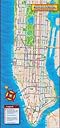

New Yorker's Manhattan Map
Product ID: 16740325
Buy anything from 5,000+ international stores. One checkout price. No surprise fees. Join 2M+ shoppers on Desertcart.
Desertcart purchases this item on your behalf and handles shipping, customs, and support to Ireland.
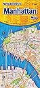
New Yorker's Manhattan Map [Opus Publishing] on desertcart.com. *FREE* shipping on qualifying offers. New Yorker's Manhattan Map Review: Accurate, helpful, and fits in my purse! - I like that there's more than just the subway system on the public transportation system, as I just can't take the subway if there are no escalators. The other map makes it easier to find things, though it can be hard to find some cross streets and even major ones. It should be resilient because it's laminated. I love that it fits in my purse, so it's is easier to carry and to get to when I need it! Review: I'm crazy about this map - When I was planning our trip to Manhattan, I wasted a lot of time looking back and forth between a street map and a subway map, trying to figure out which subway went to a certain obscure restaurant - and what station I should exit. That's why I was so thrilled to find this map - it shows subway lines, stations and streets all on one handy document. It's wonderfully compact too. Manhattan fills the front, determining the long skinny shape of the map. On the back there's a bus route map and street index for Manhattan, and a map showing subway lines throughout the boroughs. The map is tough, waterproof, and has a sensible accordion fold. I found it in a bookstore and ordered another from desertcart for my husband. We're in New York right now, as I write, and we're not lost.
| Best Sellers Rank | #1,277,327 in Books ( See Top 100 in Books ) |
| Customer Reviews | 4.2 4.2 out of 5 stars (44) |
| Edition | 2018th |
| ISBN-10 | 0972966609 |
| ISBN-13 | 978-0972966603 |
| Item Weight | 1.65 ounces |
| Language | English |
| Print length | 10 pages |
| Publication date | January 22, 2018 |
| Publisher | Opus Publishing |
B**A
Accurate, helpful, and fits in my purse!
I like that there's more than just the subway system on the public transportation system, as I just can't take the subway if there are no escalators. The other map makes it easier to find things, though it can be hard to find some cross streets and even major ones. It should be resilient because it's laminated. I love that it fits in my purse, so it's is easier to carry and to get to when I need it!
P**O
I'm crazy about this map
When I was planning our trip to Manhattan, I wasted a lot of time looking back and forth between a street map and a subway map, trying to figure out which subway went to a certain obscure restaurant - and what station I should exit. That's why I was so thrilled to find this map - it shows subway lines, stations and streets all on one handy document. It's wonderfully compact too. Manhattan fills the front, determining the long skinny shape of the map. On the back there's a bus route map and street index for Manhattan, and a map showing subway lines throughout the boroughs. The map is tough, waterproof, and has a sensible accordion fold. I found it in a bookstore and ordered another from Amazon for my husband. We're in New York right now, as I write, and we're not lost.
L**R
Excellent tool!
I purchased this map when I was planning a trip to Manhattan with students and found it extremely helpful. 1. It includes more streets and locations. This map has more streets labeled than I saw on other maps; other maps did not include some of the smaller streets. This map also includes more points of interest than other maps I've seen; In addition to museums, stores such as FAO Schwartz and Macy's are labeled. 2. It is fairly easy to read. Even with the greater detail, I didn't find the lettering too tiny or difficult to read. Another plus is, unlike other maps which split the island in half, this map shows the entire island on one side. 3. It's well-made. The entire map is laminated and easy to fold. 4. It's still a pretty convenient size. Despite the detail and the length of the map (as it includes the entire island on one side), it's still pretty handy to carry if you need to consult it on the street. Folding the map over to the section you need doesn't make it appear too bulky or overly obvious. 5. At $4.95, it's also a great value. You can get an excellent map at a lower cost than other potentially inferior maps. I had also purchased the Vandam New York City/ Manhattan, New York Pop-Up Map and was not pleased with it in comparison. I found it more difficult to locate streets and locations on this map. It didn't include as many points of interest as the New Yorker's Manhattan map. In addition, The paper construction of the pop-up map was not very durable; it's starting to tear after one trip. The Vandam New York City/ Manhattan, New York Pop-Up Map was also more expensive- $6.95. I don't usually write reviews for products, but I am pleased to recommend the New Yorker's Manhattan map for its detail, readability, durability, and size.
C**B
It just works
Just returned from NYC and although I had several maps, after a day I put the others away and just used the New Yorker's Manhattan Map. I prefer it to Streetwise Manhattan because it's a better size (slightly smaller) and to me at least, the graphics are easier on the eyes. With the subway routes and stops integrated it pretty much was all I needed to navigate. The bus routes are not as viewable since they are on a separate page and in smaller type...but other maps have the same problem. All in all this map got the job done for us, and we were all over the city on subways and buses. The only other tool that I highly recommend, and this is off-topic, is a smartphone and google maps. With a little practice (best done before you leave, and not in the rain on a NYC street corner), you can get directions from your current location to any place using public transport. I found the routing from google to be far superior to the 'dedicated' NYC iPhone apps. It's not perfect, but if you get the route and then do a 'sanity check' using the Manhattan Map the experience is outstanding and you will save yourself hours of travel time, to say nothing of avoiding that 'lost' feeling. One final tip. Look carefully at the subway stops on the map. NYC subways run several lines on the same track, and while the map DOES show which lines stop at which stations, it's easy to overlook this feature. For example in lower Manhattan the 1,2,3 lines all run on common track, but they don't all stop at each station! Also look closely at the small blue labels that identify each subway stop's name.
C**G
Well used map!
Used this map a ton! The slight laminate makes it a little water proof, which was very helpful when it was raining, or when my water bottle leaked in my bag. Clear subway routes. Text might be too small for those with poor eyesight. Overall, excellent map.
C**T
Visually pleasing and handy but not up to date!
I would never be without one of these small folding laminated maps when visiting New York -- they are incredibly handy for quick reference and safer than pulling out a phone. This one is has particular visual appeal with brighter colors and more contrast and I was excited to add it to my travel collection. It's a 2018 issue so I was extremely disappointed to discover that it still shows the OLD 945 Madison Ave location of the well-known and popular Whitney Museum of American Art. In 2015 it moved into its spectacular new Renzo Piano building on the opposite end of Manhattan at Gansevoort St overlooking the Hudson River. The Whitney is at the southern terminus of the even more famous High Line Elevated Park, which was completed all the way to 34th Street in 2014 but appears incomplete on the map. Since I recognize these errors I am still keeping the map but they could cause costly delays for the first-time visitor and need to be fixed.
Trustpilot
3 weeks ago
1 month ago